The Grand Canyon South Rim has roughly 30 named viewpoints in a 24-mile stretch. You only need five of them — and which five depends on what time of day you are there and whether you have a car. Most guides list every viewpoint with the same length of description, which is useless on the ground. After two days on the South Rim during the July 2025 field trip — dawn at Mather, the central village in mid-morning, sunset at Hopi and a separate drive to Desert View Watchtower — these are the five that mattered, and the two that the guidebooks oversell.
Named viewpoints
~30 along 24 miles of rim
Entry fee
$35 / vehicle · 7 days
Free shuttle routes
3 (Village, Kaibab, Hermit)
Best sunrise
Mather or Yaki Point
Best sunset
Hopi Point (west-facing)
East-end anchor
Desert View Watchtower (25 mi)
Quick answer: which 5 viewpoints must you see?
Mather Point, Yavapai Point, Yaki Point, Hopi Point and Desert View Watchtower are the five South Rim viewpoints that cover the full range of what the South Rim offers — from iconic first-look photography to a less-crowded sunset to the only viewpoint where the Colorado River itself is visible. Mather is the standard arrival point next to the main visitor centre. Yavapai is 1.5 miles west with the Geology Museum and a quieter rim walk. Yaki, four miles east of Mather, is shuttle-only — private cars are banned from that road year-round — and is the local sunrise pick. Hopi, on Hermit Road west of the village, faces west and is the standard sunset choice. Desert View Watchtower, 25 miles east at the far end of Desert View Drive, is the only viewpoint where you see the Colorado River curving below you in the same frame as the canyon walls.
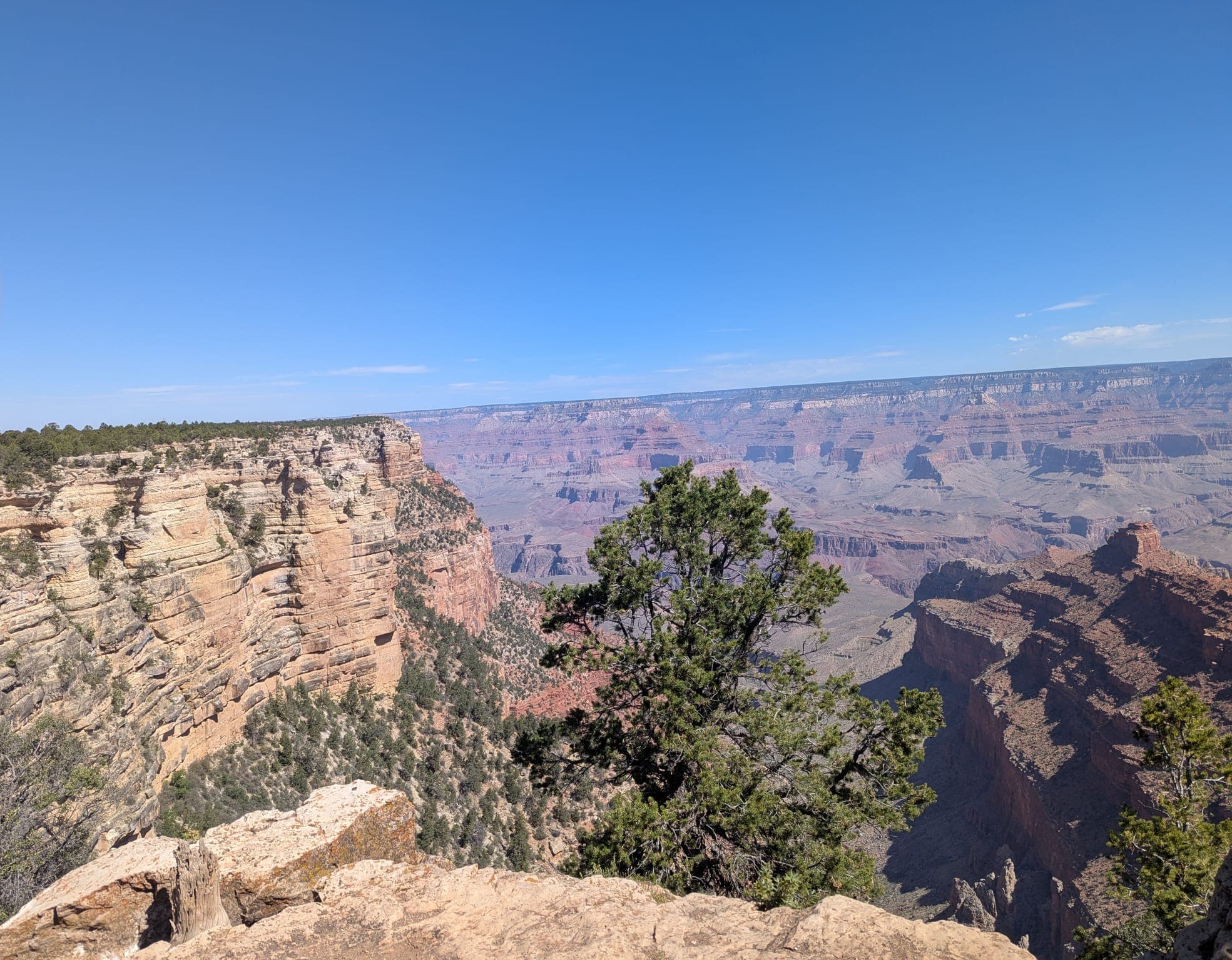
Mather Point — the iconic first look
Mather Point is the viewpoint everyone hits first, and that is the right instinct. The walk from the visitor centre is short (~5 minutes, paved, fully accessible), the rail is sturdy, and the canyon opens in a 180-degree panorama that is exactly the image you have in your head of the Grand Canyon. The composition is wide, deep, and the layered ridges recede into haze convincingly even at midday.
The trade-off is crowds. Mather is the busiest viewpoint in the park, and from 10 am to 4 pm in summer you will share it with several hundred people at any given moment. The standard fix: arrive at sunrise (45 minutes before to 30 minutes after) and you will have stretches of rail to yourself between tour groups, or come at sunset and wait out the late-afternoon bus arrivals on a bench until the light hits the canyon walls properly.
On the July 2025 visit I walked Mather at 5:40 am — sunrise was at 5:25 — and there were six other people on a viewpoint that holds maybe fifty. The same spot at 11 am that day had a coach group plus three vans and was unworkable for photography.
Yavapai Point + Geology Museum
1.5 miles west of Mather along the paved Rim Trail. Yavapai Point pairs a quieter version of the Mather panorama with the Yavapai Geology Museum — a small NPS building with a 3D relief model of the entire canyon plus interpretive panels that explain the rock layers you are looking at. For first-time visitors, the museum reframes the view: the canyon is not just beautiful, it is 1.84 billion years of stratigraphy you can read top to bottom.
Yavapai Point itself faces north-northeast, which means the dawn light at 6 am hits the far canyon wall directly and the depth reads better than it does from Mather (which faces more directly north). Photographers who know the rim usually pick Yavapai over Mather for sunrise on that basis alone. The viewpoint is also noticeably less crowded than Mather — in my experience roughly half the crowd at the same time of day — because tour buses do not stop here directly and visitors have to walk the rim or take the Village shuttle.
Yaki Point — sunrise only, shuttle access
Four miles east of the village along the Kaibab/Rim shuttle route. Yaki is structurally important to know about because it is one of two viewpoints (with Hermit Road in summer) where private cars are banned year-round. You either take the free Kaibab/Rim shuttle (it runs from 30 minutes before sunrise) or walk in.
What makes Yaki the local sunrise pick: it sits on a small peninsula of rim that sticks slightly into the canyon, which means the dawn light hits both sides of you simultaneously rather than washing across a single wall. The composition has more depth than Mather at the same time of day, and the crowd is roughly a third of Mather's — because most first-time visitors do not know about the shuttle until they read about it.
The catch: the first Kaibab shuttle from the visitor centre is timed to arrive at Yaki 30 minutes before sunrise. If your hotel is in the village, plan to be at the shuttle stop by 5:00 am in midsummer (sunrise around 5:20–5:30) — the shuttle ride itself is 15 minutes. In winter, sunrise is later (~7:20 am) and the math is much easier.
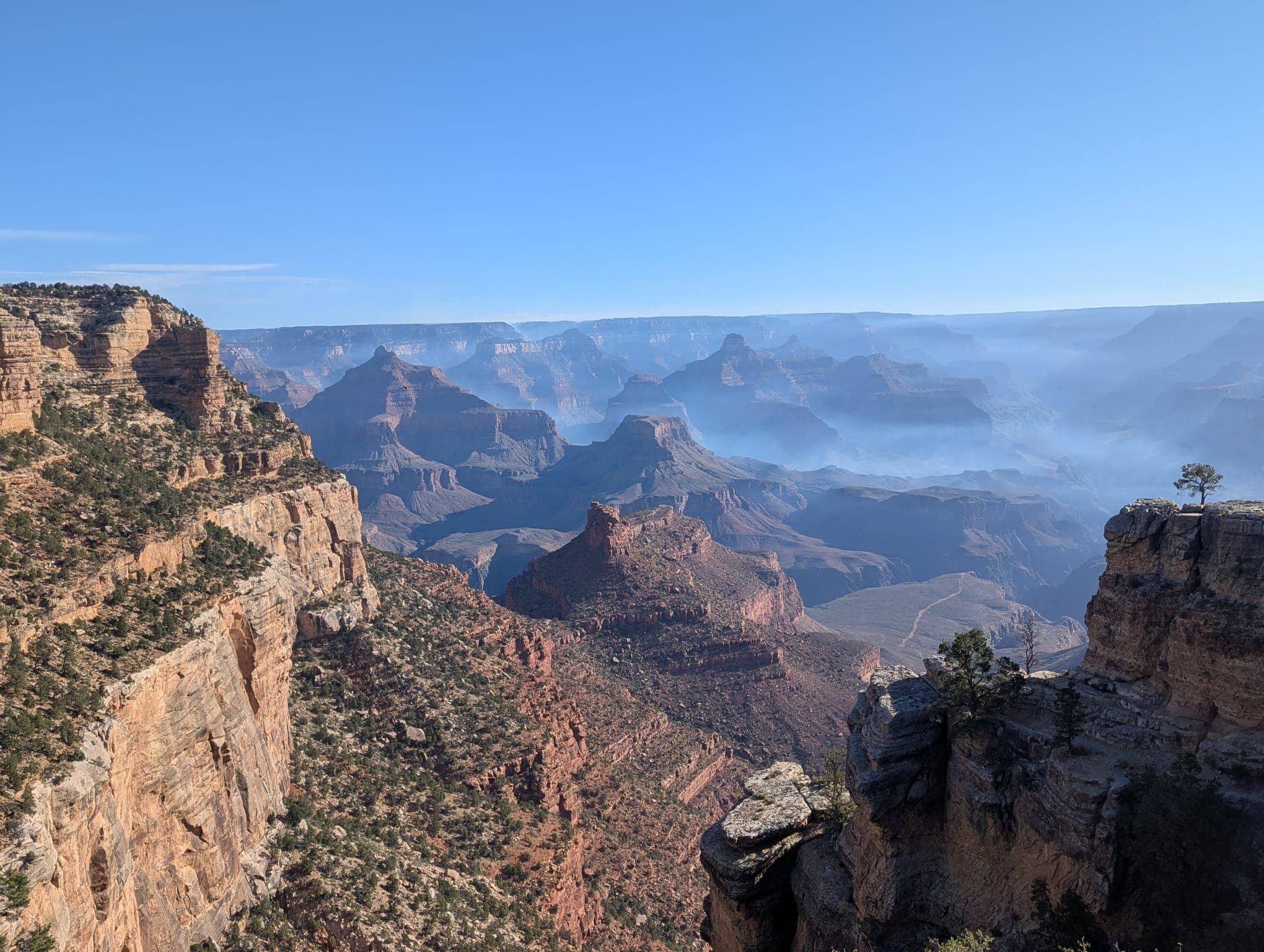
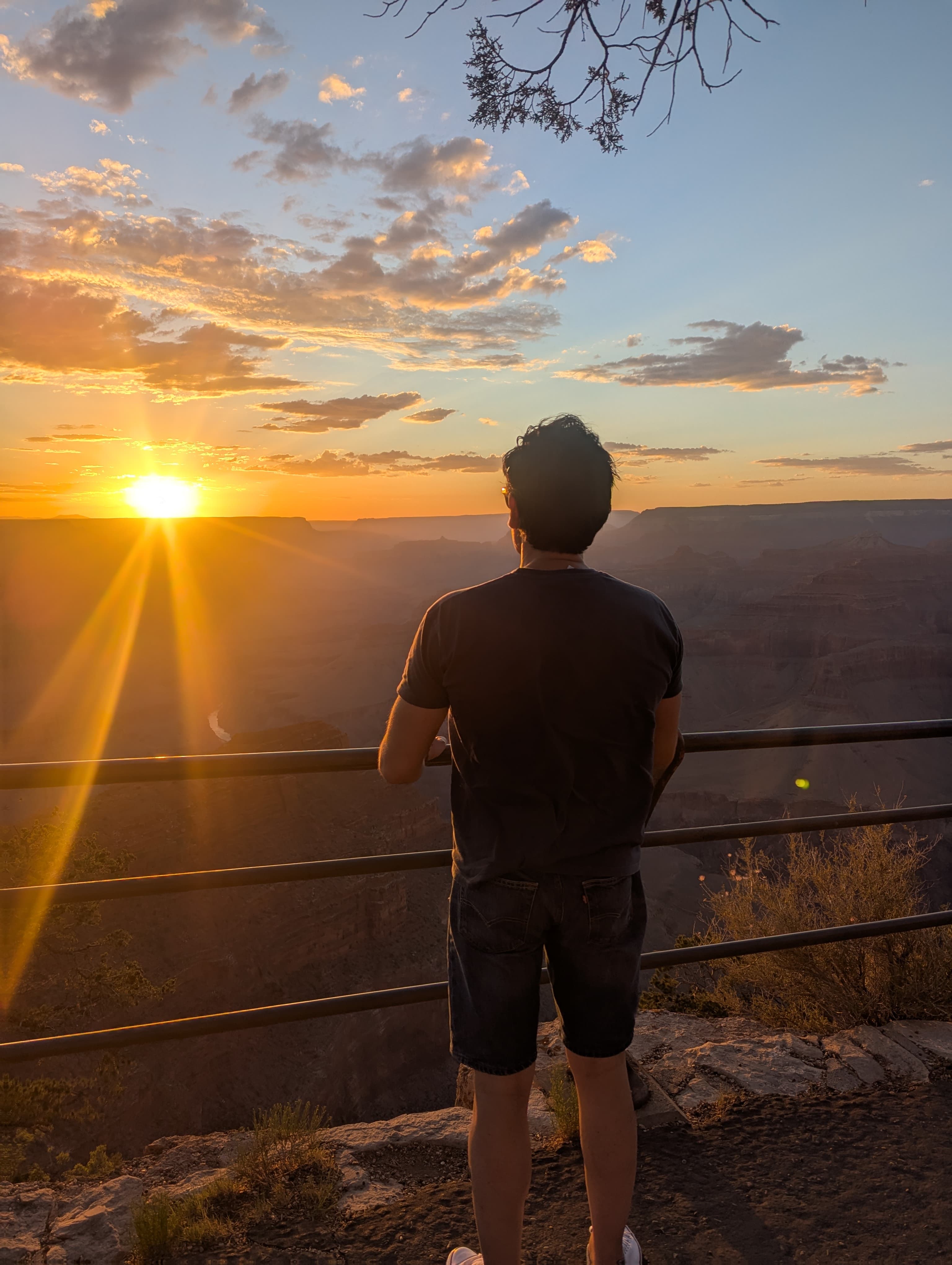
Hopi Point — the sunset answer
Hermit Road, three miles west of the village along the Hermit shuttle route. Hopi Point is the sunset pick for the same reason Yaki is the sunrise pick: it sits on a peninsula of rim that juts into the canyon, which means at sunset the light is hitting both visible canyon walls rather than only the east side. The depth of the composition is the strongest of any South Rim viewpoint after 6 pm.
Hopi is also the standard answer because it has actual practical infrastructure for sunset visitors — a paved viewing platform large enough to absorb a few hundred people without anyone losing a good spot, benches, restrooms back at the trailhead 200 m away, and the Hermit shuttle that runs late enough to take you back to the village after dark.
On my July 2025 visit I walked from the village to Hopi (1.5 hours along the Rim Trail starting at 4:30 pm) and got back on the shuttle after sunset around 8:40 pm. The light from 7:40 to 8:20 was the best of the entire trip — sustained warm tones on the canyon walls, the river barely visible as a dark ribbon at the bottom, the haze building behind the western edge.
Important seasonal note: Hermit Road is closed to private vehicles from March 1 through November 30. Outside that window (December through February) you can drive directly to Hopi and the Hermit shuttle does not run — see the winter section below.
Desert View Watchtower — the east-end finale
25 miles east of the village along Desert View Drive (also called the East Entrance Road, AZ-64). This is the one viewpoint that is too far for the free shuttle network, which is exactly why so few tour groups make it out here and why it is the calmest of the five.
What makes Desert View structurally different from the other four: you can actually see the Colorado River from here, curving below in a visible bend, with the canyon walls framing it on both sides. None of the central viewpoints (Mather, Yavapai, Yaki, Hopi) put the river in the frame — the canyon is too deep and the angle is wrong. Desert View, because it sits further east where the canyon narrows, gives you the river as part of the composition.
The Watchtower itself is a 70-foot stone tower designed by Mary Colter and built in 1932 in a deliberate echo of Ancestral Puebloan architecture. You can climb it (small donation suggested) for a viewing platform with windows on all sides — the only structure on the South Rim that gives you elevated photographs over the rim. Worth the climb even on a hazy day.
On the way to or from Desert View, Desert View Drive has six additional pullouts (Grandview, Moran, Lipan, Navajo, Pinal, Buggeln). Most are a quick stop-and-photograph rather than a full viewpoint walk. Lipan Point at sunset is the alternative if Hopi is full or you are already on the east drive.
Free shuttle routes vs driving Desert View Drive
The South Rim has three free shuttle routes plus a fourth seasonal one. They cover the central viewpoints; for the eastern end you need a car.
| Shuttle | Covers | Runs | Frequency |
|---|---|---|---|
| Village (Blue) | Visitor centre, village lodges, Mather Point | Year-round | 15 min |
| Kaibab/Rim (Orange) | Visitor centre, Yavapai, Yaki Point, South Kaibab trailhead | Year-round | 15 min |
| Hermit (Red) | 9 western stops including Hopi, Mohave, Pima, Hermits Rest | 1 March – 30 November | 15 min |
| Tusayan (Purple) | Tusayan town (south of the park gate) to visitor centre | 1 March – 30 September | 20 min |
The honest planning rule: a single full day with shuttles covers Mather + Yavapai + Yaki + Hopi comfortably. A second day with a car covers Desert View Drive end to end. If you only have one day, prioritise the shuttle stops and skip Desert View — or drive Desert View first thing in the morning and use the shuttles in the afternoon.
Sunrise vs sunset vs midday: the light mechanism
The Grand Canyon runs roughly east-west, with the South Rim looking north into the canyon. That geometry sets the light mechanic for the entire rim:
- Sunrise:sun rises in the east, lighting the canyon walls on your right (east) and inside the canyon obliquely. The far north wall is lit; the near south-facing walls below your viewpoint stay in shadow until later. Yavapai, Mather and Yaki all read well at sunrise — of the three, Yavapai's north-northeast orientation gives it a slight edge because the dawn light hits both the far wall and the upper canyon walls at a shallower angle than at Mather.
- Sunset: sun sets in the west, lighting the canyon walls on your left (west) and the near south-facing walls below you. Hopi, Pima and Lipan all read well at sunset. The walls below you turn from grey to warm orange in a 20-minute window starting roughly 40 minutes before sunset.
- Midday (10 am–3 pm): light is overhead. The canyon walls all receive similar exposure and the layered depth flattens. This is the worst window for photography but the most comfortable for visiting — temperatures are mild even in winter, restrooms and food are open at the village.
- After sunset (blue hour, ~30 minutes): the canyon walls go flat dark but the sky stays bright and saturated. Hopi is the standard choice for blue-hour photographs. Bring a tripod (allowed on rim viewpoints, unlike inside Antelope Canyon).
Hermit Road in winter (the bike option)
From December 1 through end of February, the Hermit Road shuttle does not run and private vehicles are allowed on Hermit Road (March 1 through November 30, the road is closed to cars and only the Hermit shuttle runs). For visitors travelling in winter, this is a genuinely different experience than the summer rim:
- Drive Hermit Road end to end with stops at Mohave, Hopi, Pima and Hermits Rest. The road is 7 miles each way; allow 2.5 hours with stops. Sunset at Hopi is still the photography pick.
- Bike Hermit Road in summer when private vehicles are banned and the shuttle is running. The road is paved, has minimal climbs, and the shuttle has bike racks so you can do half by bike and half by shuttle. Bikes can be rented at Bright Angel Bicycles in the village.
- Yaki Point road remains closed to private vehicles year-round — winter or summer. The Kaibab/Rim shuttle is the only way in.
Frequently asked questions
Which Grand Canyon South Rim viewpoint is the best?
Mather Point is the most popular and the standard first-time view — wide canyon panorama, easy access from the main visitor centre, and the iconic Grand Canyon photograph composition. For depth and a less-crowded experience, Hopi Point (sunset) and Desert View Watchtower (sunrise or sunset, plus the Colorado River visible below) are the two that most repeat visitors prefer. The honest answer: visit Mather first, then Hopi, then drive 25 miles east to Desert View — those three cover the range of what the South Rim offers.
Do you need a car to see the South Rim viewpoints?
No, not for the central viewpoints. The South Rim has three free shuttle routes — the Village and Kaibab/Rim shuttles run year-round (covering Mather, Yavapai, Yaki and the visitor centre), and the Hermit shuttle runs March 1 through November 30 (covering Hopi, Mohave, Pima, and Hermits Rest). For Desert View Watchtower (25 miles east of the village), a car or paid tour is necessary — the free shuttles do not run that far. Yaki Point is shuttle-only year-round — private vehicles are banned from that road.
How much does it cost to enter the South Rim?
$35 per private vehicle as of 2026, valid for 7 days and including the North Rim. Motorcycles pay $30, individuals on foot or bicycle pay $20. An America the Beautiful annual pass ($80) covers all national parks including Grand Canyon — worth it if you visit 2+ parks in a year. The pass is sold at the entrance booth, online, or at the visitor centre.
Is the Grand Canyon South Rim accessible by wheelchair?
Yes, more than most national park rims. The paved Rim Trail between Mather Point and Yavapai Point (about 0.7 miles) is accessible. Mather, Yavapai, Hopi and Desert View have paved walks from accessible parking. The Grand Canyon Accessibility Permit (free, available at the visitor centre or in advance) opens otherwise-restricted roads including Yaki Point and Hermit Road to permit holders. The full accessibility map is published by Grand Canyon NP on the NPS site.
What is the best time of day to visit the South Rim?
The best time to visit the South Rim is at sunrise or sunset — sunrise (45 minutes before to 30 minutes after) for the cleanest light and emptiest viewpoints (Mather Point or Yaki Point are the standard choices), and sunset for the warm-tone canyon photograph that dominates the postcards (Hopi Point on Hermit Road is the answer). Midday is the worst for photography (flat overhead light flattens the depth) but the most comfortable for general visiting. If you only have one window, sunset at Hopi.
How far is the Grand Canyon South Rim from Las Vegas?
About 280 miles (450 km) by road, roughly 4.5 hours each way via Kingman and Williams. The West Rim — a different and less impressive section operated by the Hualapai tribe — is only 125 miles and 2.5 hours. Most Las Vegas day-trip helicopter and bus tours go to West Rim, not South Rim. If you specifically want the South Rim photographs, it's an overnight trip or a long charter-flight day. Helicopter day tours from Las Vegas to the South Rim exist (Papillon, Sundance) but cost $700-900.
About this guide
Written by Diego Fresno, travel writer and independent publisher specialising in the American Southwest. This South Rim guide draws on two days at Grand Canyon Village in July 2025 — including dawn at Mather Point, mid-morning along the Rim Trail to Yavapai, sunset at Hopi Point, plus a separate drive east to Desert View Watchtower — cross-referenced with current NPS shuttle and accessibility schedules confirmed in May 2026. Verified quarterly — last review April 2026. About the author →
Related guides
Grand Canyon: the complete 2026 guide
South Rim vs West Rim, helicopter tours, getting there from Las Vegas, when to visit and what to expect.
Best Grand Canyon helicopter tours from Las Vegas
Papillon, Maverick, Sundance, 5 Star and the fixed-wing alternative — operator-by-operator review with current prices.
Antelope Canyon + Horseshoe Bend in one day
If you are combining South Rim with Antelope and Horseshoe Bend: exact driving route + tour timing.
Page, Arizona itinerary: 1, 2 or 3 days
How to fit South Rim into a Page-based road trip with Antelope, Horseshoe Bend and Lake Powell.